
This is the first in a series of four posts about temples located in Morena district of Madhya Pradesh, but which lie close to and are easily accessible from Gwalior. I’ve been reading about these temples for a few years now and was eagerly waiting for a chance to visit them, which I got when I visited a friend in Gwalior. Morena is a long and narrow district in northern MP which follows the path of the Chambal River on the border between Rajasthan and MP. This is why Morena is closely associated with the Chambal ravines and the dacoits who used to live and operate there. This association with the land of the Chambal dacoits gives an added layer of excitement to visiting these temples. The district’s southern border comes very close to Gwalior city, which is how the temples can lie in Morena district but be close to Gwalior.
Nareshwar is the closest site to Gwalior, just 20km distant from the city center, and is accessible via a dirt track to the left of the Gwalior-Bhind road before Malanpur. All the other temples are accessible by turning left at Malanpur and driving a little into the interior of Morena district. On this trip I didn’t get to visit all the temples on my list, but that just leaves sites to be visited on a future trip, and the sites I did get to see were quite spectacular.
All the four sites I visited: Nareshwar, Aiti, Mitaoli and Bateshwar are located on or near rocky outcrops or hillocks that rise above the surrounding plains. Of course Gwalior Fort is famously on a high rocky outcrop as well. These outcrops indicate an interesting aspect of the geographical location of all these sites. They are situated in the boundary zone between the alluvial Gangetic Plains to their north, and the vast rocky peninsular block of India to their south. These rocky outcrops therefore represent and form the edge of the peninsular block. Often the popular idea of the peninsular block of India is that it starts south of the Vindhyas and is contiguous with just the Deccan Plateau. However, north of the Vindhyas lie what are collectively known as the Central Highlands, which also form part of the peninsular block. Much like the Deccan Plateau and the Eastern Plateau (Chota Nagpur etc) of the peninsular block, the Central Highlands are also made up of smaller plateaus, uplands and hill ranges. The Aravalli range, running from northern Gujarat, through Rajasthan and up to Delhi, forms the western edge of the Central Highlands and peninsular block. This block, collectively also known as the Peninsular Plateau, along with the Himalayas and the Gangetic Plains, consist of the largest geographical regions of India that cover most of country’s landmass.
The wide Gangetic Plains are a “depression” between the Himalayas and the Central Highlands, that have been filled over millions of years by alluvial deposits from Himalayan rivers. The rocks at the bottom of this depression are a continuation of the peninsular block, but are now covered with more recent alluvium. Where the bed-rock of this alluvium-covered depression emerges back on to the surface of the earth is this boundary zone that I’m talking about. This zone follows a shallow-crescent line somewhat parallel to the HImalayan range, extending from the Agra-Dholpur area to the west, passing through the Gwalior area, Chitrakoot, south of Allahabad and Varanasi to Sasaram, and then to Jamalpur, Bhagalpur and Sahibganj in the east.
On the ground, this means that the vast area of flat plains that extend southwards from the Himalayas start getting interspersed with the kind of rocky outcrops or hillocks that the temples of Nareshwar (or Naresar) are situated on. South of this boundary zone, the bed-rock of the peninsular block emerges completely from under the alluvium deposits of the northern depression.
From an architectural history standpoint, I think the location of these temples in this boundary zone might be significant. Around this boundary zone and south of it, stone becomes readily available as a building material, and we immediately start to see examples of these stone temples, literally on the first few outcrops of peninsular stone bordering the northern plains. This is not to say that stone construction is not present in the plains, but the frequency of stone use possibly becomes much more in this area and south of it. In the plains, there might be a preference for brick masonry and plaster work, indicating the materials easily available there. There existed and exists a lot of stone construction north of the Gwalior area in and around Delhi, Mathura, Agra etc, but these are either on or very close to the Aravalli range, which is a ready source for such stone construction material. In fact Dholpur, which is also situated in this boundary zone, is synonymous with stone quarrying from such rock outcrops and hillocks. And of course when one gets to the Himalayas north of the plains, stone becomes a readily available construction material once again.
All this is just a speculative hypothesis for now, though I’m sure that the existing literature on Indian architectural history would have a lot of data that would either end up supporting or refuting this idea. The hypothesis could be summed up in the following (pretty simple) queries: “Is there a comparatively reduced usage of stone as building material in the northern alluvial plains, in areas that are further away from the Central Highlands and Himalayas”, or the flip side of the same question: “Is there a more frequent occurrence of stone construction, especially stone temples, in areas of the Central Highlands than in the Gangetic Plains?”
This might be even more true of earlier eras in Indian history than more recent ones, with many examples of stone temples existing from the Gupta (4th-6th c AD) and Pratihara (8th-11th c AD) eras in this boundary zone and south of it, than in the northern plains. Sites of Gupta era stone temples such as Nachna, Bhumera and perhaps Bateshwar lie in this zone (and many more south of it), whereas to the north in the plains lies one of the few remaining examples of Gupta era brick temples at Bhitargaon.
The answers to these questions can be ascertained with more research. Clearer images of these rocky outcrops overlooking the fertile plains below can be found on my post about the nearby temple at Mitaoli, as well as on my writeup about the wanton destruction of such outcrops by stone quarrying activity for India’s booming construction industry. For now I’ll return to the site at hand: Nareshwar.
Nareshwar
The southern approach to the Nareshwar group of temples is from the base of the rock outcrop that the temples are situated on. I visited the temples in mid-December on one of the foggiest mornings of the year, so didn’t get to see views of the area around. The temples at Nareshwar were built between the 8th and 12th c AD, the earliest built during the early Pratihara period.
On the way up the rocky hillock to Nareshwar:
 Plateau-land on top of the hillock:
 A view from the north of the valley that the Nareshwar temple complex is situated in. You can click on the image for a larger view and discern the temple complex to the left of the large tree in the middle-ground.
 On the southern approach to the temple complex, a more modern small shrine and pir grave side-by-side, creating a syncretic pair!


The Nareshwar temple group occupies a narrow ravine that opens into a small valley in the wide rock hillock. The bed of this ravine consists of a series of terraces, on which the temples are built. As we approach the temples from the south, we crest the plateau-land of the hill, then slowly begin descending into the ravine and begin to encounter the temples. The seasonal stream which created the ravine and valley is still active, and visiting the temple complex during the monsoons, when the stream would be at its most active, should be a great experience.
The first few temples/shrines one encounters from the southern approach, at the start of the ravine:


 As we go a little deeper into the ravine, we get our first view of a tank around which are built a few shrines and ghats (steps) into the tank. The ghat steps have been artificially carved out of live rock.


 Space for more shrines:

Shrines and ghats:


 The water channel outlet for the dammed tank seems to have been artificially carved out as well.

 Larger temples in the lower terrace of the ravine:


 A side group of shrines:
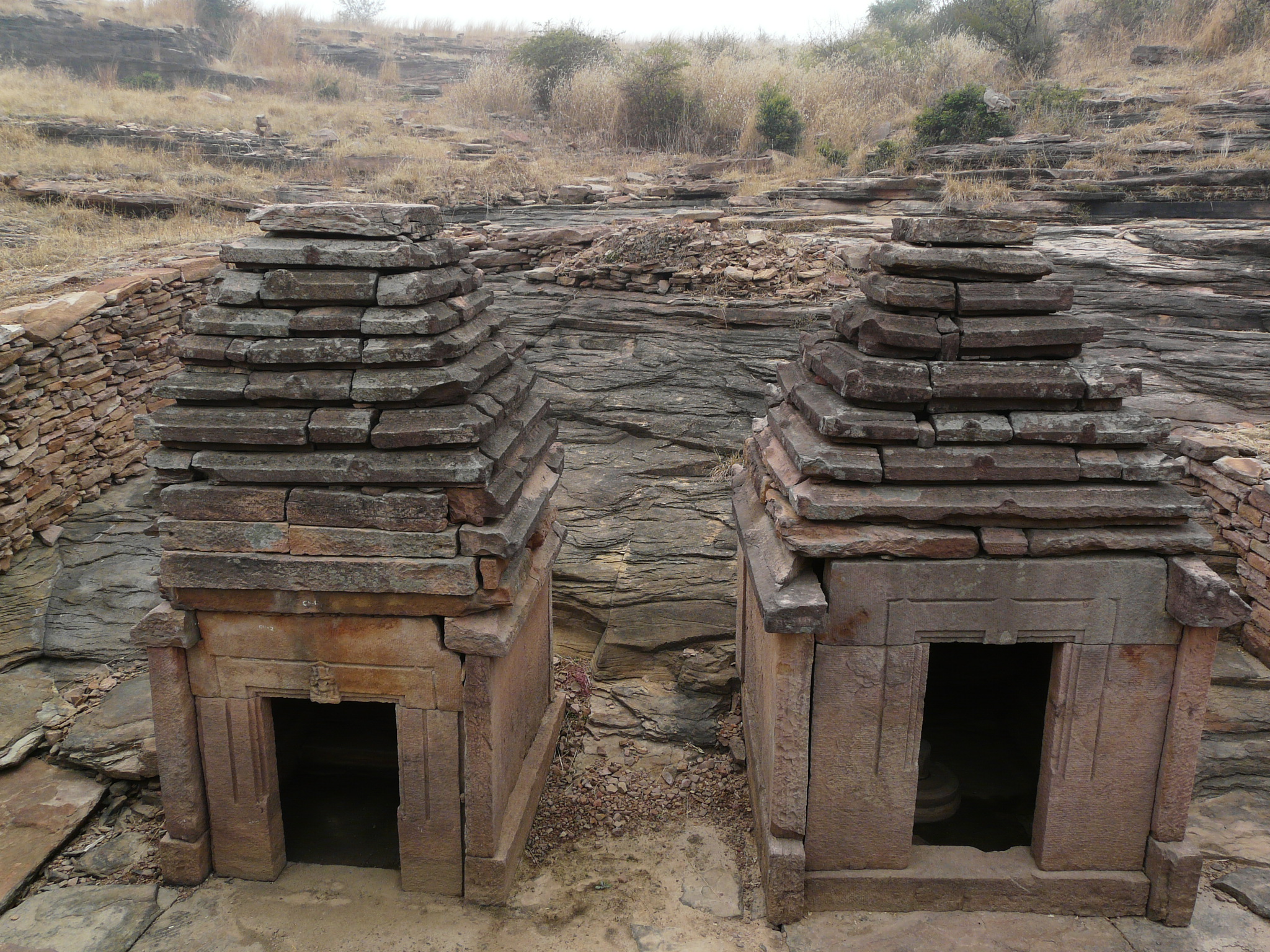
 The main group of temples on the lower terrace, where restoration work was ongoing:


 One of the temples has an unusual “khakara deul” style shikhar (spire), possibly indicating a goddess temple dedicated to one of the manifestations of Shakti:


 Sculptures on the ground:


Spectacular indeed! I need to come for another architectural historians trip! Can you say more about the khakara deul? What does that mean?
LikeLiked by 1 person
Avigail it’s a particular temple style. The sanctum is rectangular instead of the usual square. Usually, the tapering shikhar (spire) above a square sanctum culminates in a (theoretical) point, and is topped with a circular disk finial or spherical finial (in south India for example). With this rectangular sanctum, the spire is also tapering but the top is a “ridge” instead of a “point”, and the finial is like an elongated vault, representing the ridge. In this way these sanctum spires are similar to the spires of the rectangular gopurams (entrance gateways) of south Indian temples, in that they have these vault-shaped finials. In a few days I’ll post photos of Teli ka Mandir in Gwalior Fort, which is a much larger example of the same khakara deul style.
LikeLike
Pingback: Temples in Morena District, near Gwalior, Part 2: Aiti | Sarson ke Khet
Reblogged this on Voices and Visions and commented:
Really fascinating photos…
LikeLike
Pingback: Temples in Morena District, near Gwalior, Part 3: Mitaoli | Sarson ke Khet
Pingback: Temples in Morena District, near Gwalior, Part 4: Bateshwar | Sarson ke Khet
Pingback: The Fate of Rocky Hills/Outcrops All Over India | Sarson ke Khet
Thank you, Sir. I am indebted to you for uncovering & sharing such rare vestiges of our unparalleled heritage.
LikeLiked by 1 person
Thank you!
LikeLike
Beautiful Write up and photos ! The Nareshwar temple with Khakara roof looks like smaller version of Teli ka Mandir in Gwaliar Fort including the khakhara roof and carving on door frame, particularly the bottom right, bottom left and top central sculptures of women.
LikeLike