
As always, click on image to go to its flickr set
Chirag Dilli
I’m finally back to my Dilli Darshan project, and so finally went to Chirag Dilli! This is the “urban village” I had posted an aerial image of in November, which was an almost perfect square from that view. On the ground, of course, things were not that orderly.
(In my mind, I wrote that last sentence as a hilariously wild understatement!) :)
Here’s the aerial image of Chirag Dilli again

Visiting these urban villages in Delhi is becoming really interesting. The reason why many of them contain such old and historic buildings, is because they were originally settlements that grew around those buildings in the first place. So, many of the sites have been settled one way or another for nearly as long as the historic buildings I go to visit in them have existed. But as these settlements have morphed into so called “urban villages” within Delhi over the past few decades, “real estate pressures” have led to encroachment and destruction of many of the historic buildings, much like a child cannibalizing an old mother it no longer needs.
Click here for an explanation of what exactly an urban village is, which involves a little description of the history and growth of Delhi over the past few decades.
And yes I know that it is problematic to call the buildings I’m visiting “historic” when the settlement/village itself is nearly as old, and that I’m favoring the investigation of specific (locally canonized) buildings over the settlement and it’s inhabitants, but since that’s what the Dilli Darshan project is all about, I’m giving myself a pass! And anyway, these buildings do deserve to be preserved!
Here are some examples of said encroachments, from Chirag Dilli as well as other places. I’m putting them up not so much as some kind of proof or evidence of illegal activity, but mainly because I find these situations – the juxtapositions of old and new in these ways – quite fascinating, in both a physical/architectural sense as well as a social/cultural sense. In terms of a real expose on Delhi’s encroachments, this doesn’t even come close to scratching the surface!
Chirag Dilli

Chirag Dilli … another part of the same monument as from the image above

In some places, the village closely skirts the monument
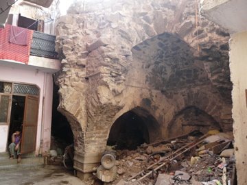
And sometimes the monuments themselves are inhabited

The village comes as close as it can even to the big monuments, like the Begampur masjid at Begampur

This is/was the Baradari at Shahpur Jat
Each urban village, of course, has a unique history. Chirag Dilli grew around the dwelling and then shrine of the Sufi saint known as Chirag Dilli (literally meaning “Light of Delhi”), who lived at this site in the 14th century. The settlement grew within the 18th century walls built around the shrine. This wall, though now nearly completely destroyed, still gives the urban village it’s present shape.
This turret is part of the very meager remains of Chirag Dilli’s erstwhile encircling walls

The east gate of the former wall

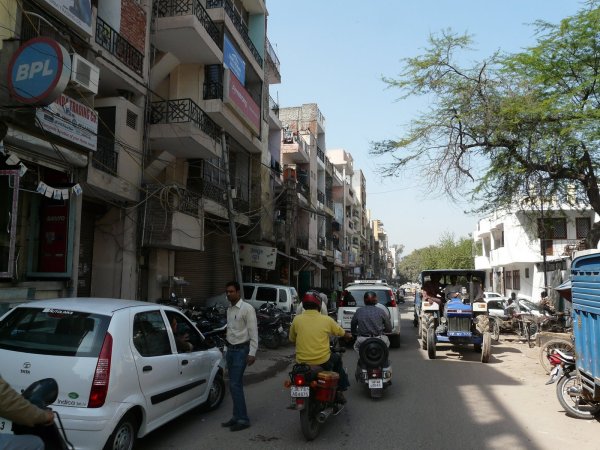
The north gate with a typical Delhi mini-traffic jam!

This is what the village edge looks like today (now you know what I mean about the extent of “encroachment”!) :)

The Chirag Dilli shrine itself is a collection of old (starting from the 14th century onwards) and new buildings set haphazardly in a small open space surrounded by the village.
Entrance to the shrine

Inside the shrine


It’s interesting to imagine what the site would have felt like at different times through the past centuries. The shrine is close to the western edge of the village, next to which would have been the reservoir created by the Satpula I had photographed earlier. So at one point, the shrine could have been close to the edge of the reservoir with a lot of open space around it. Then the village and walls would have grown around it, and that growth has ultimately resulted in the Chirag Dilli we see today! (or something like that) :)
The pulls and pressures of growth, development and conservation that have created these spaces in urban villages and other places are really fascinating, and I’m going to report on them more and more as I continue this project, methinks.
Old and new buildings and spaces within Chirag Dilli

A Delhi Development Authority (DDA) housing colony just south of Chirag Dilli. In the aerial photo above, these are the ordered blocks at the lower edge of the image. This is a typical view of “planned” Delhi, in contrast with “urban village” Delhi

Siri: Encroachment, Development and Conservation
A prime example of the above mentioned pulls and pressures is the fortified town of Siri. Siri predates Jahanpanah (which contains the Begampur and Khirki as well as Chirag Dilli sites), and I had visited it before but lost the photos to a hard drive crash. I went back there again recently and believe it or not lost the photos again, but was able to recover the “thumbnail” versions, which is why the Siri photos are so small.
Siri contains yet another urban village, called Shahpur Jat, with it’s inevitable encroachments, but is interesting because it was also the site of a major development project for the 1982 Asian Games, and will again be a venue for the 2010 Commonwealth Games. Bordering Siri to the south is one of south Delhi’s planned “colonies”, and the intersection of the fortification and the planned neighborhood creates an interesting edge-space.
Aerial photo of Siri

And here’s the aerial again with tags. The different densities and built fabric of the urban village and “games village” (as well as the large forest) within Siri, and the residential colonies surrounding Siri are apparent (Panchsheel Park is directly to the south of Siri) . Siri’s walls form an “island” in the urban fabric of planned colonies and neighborhoods of south Delhi

Tohfe Wala Gumbad, on the edge of Shahpur Jat, is an early 14th c. mosque, even though it looks like a tomb at first glance and is also named as such (only the central domed chamber remains intact – the side arcades are nearly completely destroyed). This structure seems to be a predecessor to the style of buildings built by and around the time of Firoz Shah Tughlaq, which are among my favorites in Delhi. This style is characterized by bold massing, clean lines, an austere look, lack of ornament, and slightly battered walls. I especially love the simple and clean arches of this style and time period.
Again, these are really small images, but I hope they can convey what I want to get across.
Tohfe Wala Gumbad

The Baradari is a large building inside Shahpur Jat, but has been encroached upon almost completely. It is only visible at some points, and looks like it’s going to vanish completely pretty soon! I wondered what the roof of the Baradari would look like, surrounded by all this new construction but, I think I saw a building on top of the roof as well!
Baradari, or what’s left of it

The remaining fortifications of Siri have been used as an excuse to halt the incessant march of Delhi’s urban growth. In this way, the walls have again served their purpose of a barrier against outside forces! :)
Half of the space enclosed by the fortifications (other than Shahpur Jat and the Asian Games village) is given over to the Siri city forest. Outside the fortifications, it is interesting to see how close the tony Panchsheel Park colony has come to the walls, with its chauffeur-driven luxury cars parked almost on top of the walls!
Walkway along Siri Fort walls being developed for the 2010 Commonwealth Games in Delhi

This part of the Siri fortifications is included in a prominently located park that was developed for the 1982 Asian Games in Delhi, and which gives the impression of a well preserved Siri

Panchsheel Park with its middle class housing, middle class cars, and “planned” layout, extends right to the walls

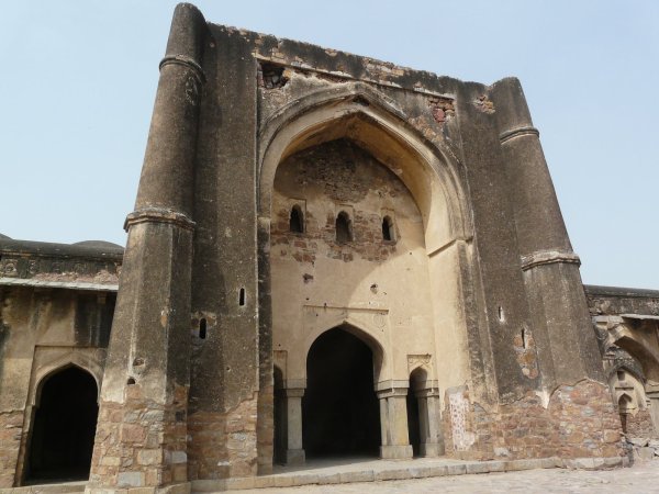
Ghiyassudin’s tomb
Ghiyasuddin Tughlaq was the founder of the Tughlaq dynasty, and his tomb (early 14th c.) contains ornamental elements from the earlier Khalji style (especially as seen at the Alai Darwaza in the Qutb complex), but also hints at elements of later Tughlaq architecture.
The tomb and it’s surrounding fortifications

Entrance through the fortifications

The interior of a side tomb looks like its from the European/Levant medieval period

Revisits
I also revisited some sites – the mosques at Begampur and Khirki, as well as the Qutb complex. Here are photographs of the revisits. Some of the Qutb photos are again small in size since they’re thumbnails only.
Begampur mosque
Khirki mosque

Qutb complex


Very Nice Pics
LikeLike
This is one of the more interesting sites I’ve discovered in recent times. Both History & Photography, delicious :) Shall come for more. There’s a lot of good stuff in the old posts too that’ll have to be read and savored.
LikeLike
Thanks so much for the comment! Glad you liked the blog!
LikeLike
Great to see Chirag Delhi monuments acknowledged by someone. I have born and brought up among those lanes which you have photographed.It took me sometime even after passing college to realize the archelogical importance of my village.Infact you missed quite a lot of places which are lost under the encroachment done by generations of families living over here. Infact you missed out the most prominent Behlol khan lodi’s tomb which lies adjacent to the dargah in a drab place.
Appreciate your work on noticing and acknowledging something which has been buried under status quo.
Regards,
Rohit Bhardwaj
LikeLike